McGarry Project
Project Summary
The McGarry property is in Virginiatown, Ontario, within the Abitibi Greenstone Belt and spans 2.4km on one of the world's most prolific gold structures, the Cadillac Larder-Lake Break. The Property encompasses 681 hectares and is comprised of 46 Patented Mining Claims and 5 Mining Licenses.
McGarry hosts a NI43-101 indicated resource of 123,000 oz at an average grade of 7.7g/t gold (uncut or 112,000 ounces with grades top-cut to 51.4 gpt) an additional inferred resource of 30,000 oz. At an average grade of 5.3 g/t (uncut or 29,000 ounces with grades top-cut to 51.4 gpt) per McGarry resource estimate from 2009 (see cautionary note at the end). McGarry also has a NI 43-101 Preliminary Economic Assessment, published in 2011, based on McGarry's 2009 resource estimate.
Location and Infrastructure
McGarry is located east of and immediately adjacent to the Kerr-Addison Mine, one of Canada's largest gold mines producing over 12,000,000 ounces gold over 58 years ending in 1996 (Figure 1) (see MNDM OFR5831). Adjacent to the west of McGarry is Bonterra Resources' Cheminis Mine and Bear Lake deposit, which host a historic estimate* (2011, P+E Mining) of 3,750,000 tonnes at 5.7 g/t (683,000 oz) (inferred) and the Cheminis Deposit contains a historic estimate (2011, P+E Mining) of indicated of 335,000 tonnes at 4.1 g/t (43,800 oz) and inferred of 1,391,000 tonnes at 5.2 g/t (233,400 oz). Bonterra's Technical Reports are available at www.sedar.ca.
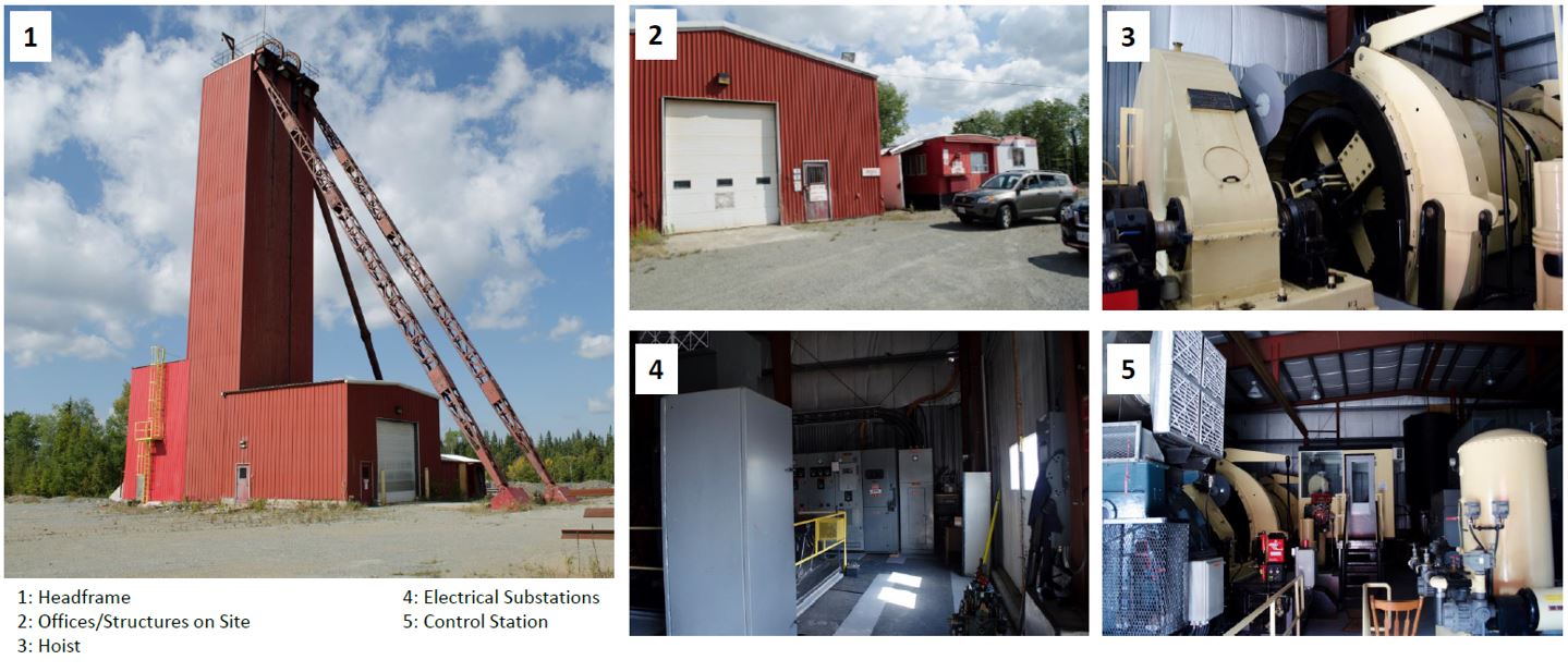
Onsite infrastructure includes a head frame, shaft compartments, hoist, offices, and fully functional core shack, all refurbished over the last ten years. McGarry is easily accessible with the Trans-Canada Highway running directly through the Property.

Mineral Resources
McGarry Historical Mineral Resource
The McGarry Property was the subject of a PEA study in 2011 that outlined a historical mineral resource of 447,000 tonnes grading 7.89 gpt gold for a total of 112,000 gold ounces in the Indicated Category and an additional 157,000 tonnes grading 5.83 gpt gold for a total of 29,000 ounces in the Inferred category (Table 1 below). This estimate was based on a 3.43 gpt Au lower cut-off with assay grades limited to 51.4 gpt gold. The specific gravity of 2.79 grams per cubic metres was used along with a minimum horizontal mining width of 1.5 metres. The report is available at www.sedar.ca under Kerr Mines Inc., and its amended version was published on 30 September 2011.
McGarry Historical Mineral Resource Estimate, Armistice Resources 2011 Technical Report

Refer below for the caution on historical mineral resources and mineral reserves.
As recently as 2013, the McGarry Mine was in production from significant underground workings and underwent underground exploration. Kerr/Armistice spent considerable capital upgrading the McGarry's infrastructure, including the shaft, hoist and onsite facilities necessary to mine underground. Additionally, extensive underground exploration yielded outstanding grades over very long lengths, including
325 N Zone – 2280 sublevel
- 8.2 g/t gold over 98m length and 1.5m width, Stope #1 (E & W)
- 4.6 g/t gold over 26m length and 1.3m width, Stope #1.5 (E & W)
- 7.6 g/t gold over 79.2m length and 1.4m width, Stope #2 (E & W)
325 N Zone – 2330 sublevel
- 11.1 g/t gold over 24m length and 1.7m width, Stope #1 (E)
- 6.1 g/t gold over 7.6m length and 1.2m width, Stope #2 (E)
- 4.3 g/t gold over 7.6m length and 1.8m width, Stope #2 (W)
440 N Zone – 2250 level
- 6.2 g/t gold over 18m length and 1.6m width
The above exploration results and grades include 35% dilution and are reported from Kerr Mines news release April 22, 2013 which is available on Sedar.com.
Barber-Larder Open Pit
The McGarry Property also hosts the Barber-Larder open pit that produced 70,000 tonnes of materials. Approximately 51,000 tonnes were processed at the Kerr Mill, which returned 6,700 ounces of gold for an average reconciled grade of 4.1 gpt gold (see MNDM AFRI file 32D04SE0006). This property area and its historical production are distinct from, although abutting, the McGarry shaft zone's production and resources.
Property Geology
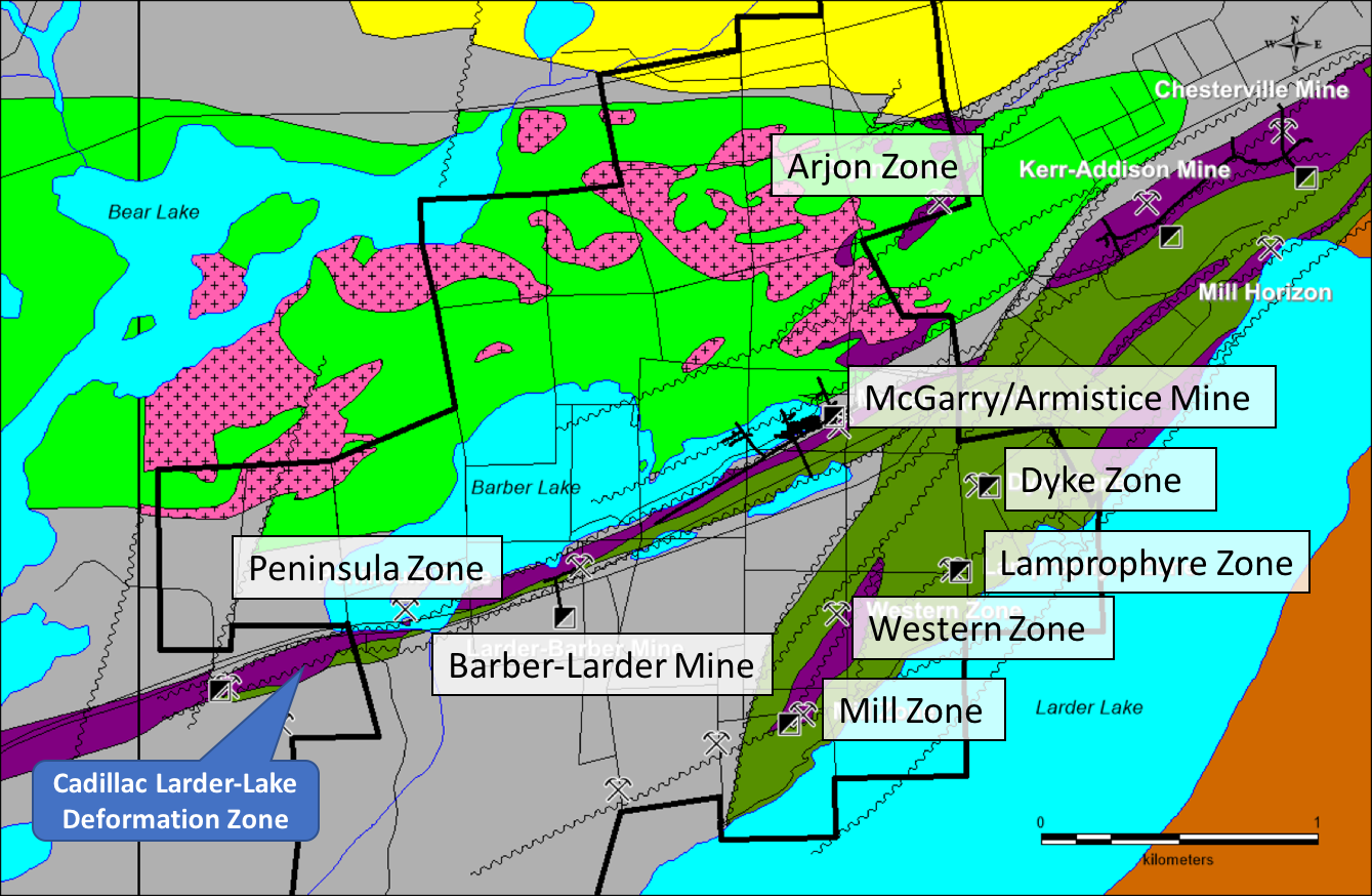
The McGarry property straddles the Larder Lake Cadillac Deformation Zone (LLCDZ), which defines a major crustal structure separating rocks of different assemblages. To the south of the LLCDZ, rocks of the Larder Lake Group (Tisdale Assemblage) are overlain by and in fault contact with conglomerate, turbidites and shales of the Temiskaming Assemblage (<2674.3 ±3.7Ma) that have been folded into a southwest plunging syncline structure.
Within the LLCDZ, the same units as above are present but highly deformed and stretched out into bands parallel to the deformation zone. The Armistice deposit contains the same ore facies as found at the Kerr Addison, namely: Carbonate ore, which corresponds to deformed and altered ultramafic rocks, "flow" ore, which is a mylonitized tholeiitic volcanic, Graphite ore which corresponds to deformed, Iterflow graphitic sediment and the mineralized porphyry dykes.
Maps and Sections
Exploration on the McGarry Project will focus on the main mineralized horizon along the Larder Lake Cadillac Deformation Zone (LLCDZ) on the one hand and evaluating the targets off to the north and south on secondary splays of the LLCDZ. The program will require a minimum of 5,000 metres to complete testing:
- Along the LLCDZ, the favourable horizon requires drill testing between the shaft and the Kerr Addison Property boundary to the east below 1,000 metres vertical and between the Larder Barber shaft and the western boundary of the Property. Also, the area between the Larder Barber shaft and the western drift on the 2,250-foot level requires more drilling.
- To the south of the LLCDZ is the Mill Zone and Lamprophyre Zone. They are located alongside a parallel structure to the LLCDZ and extends onto the Kerr Addison Mine property to the east.
- To the north of the LLCDZ, the Arjon Zone is located along a low-angle splay of the LLCDZ that extends to the northeast and intersects some ultramafic horizons in volcanics of uncertain age but possibly of Tisdale association. The structure is known to contain gold but has not been drilled since the 1940s and then only at very shallow depth.
3D Models
3D Fly-By Video of McGarry Shaft Zone
3D Fly-By Video of McGarry Shaft Zone
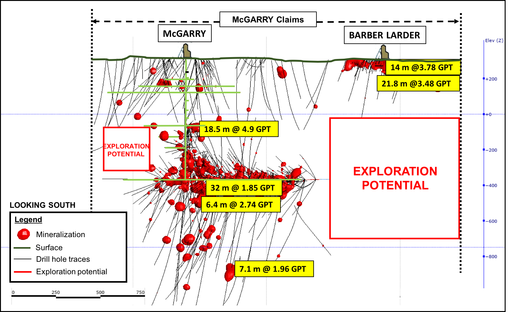
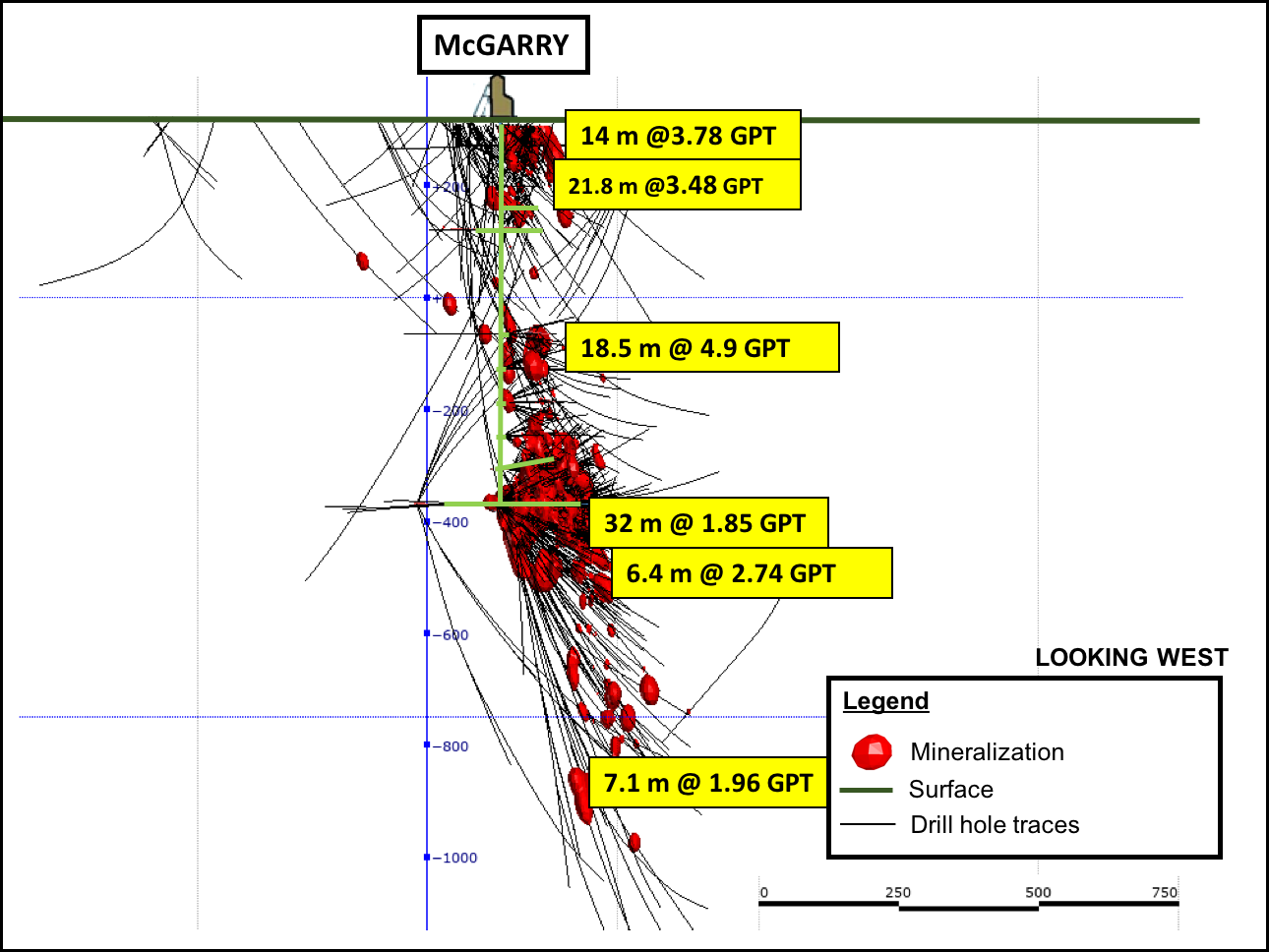
McGarry Exploration Potential
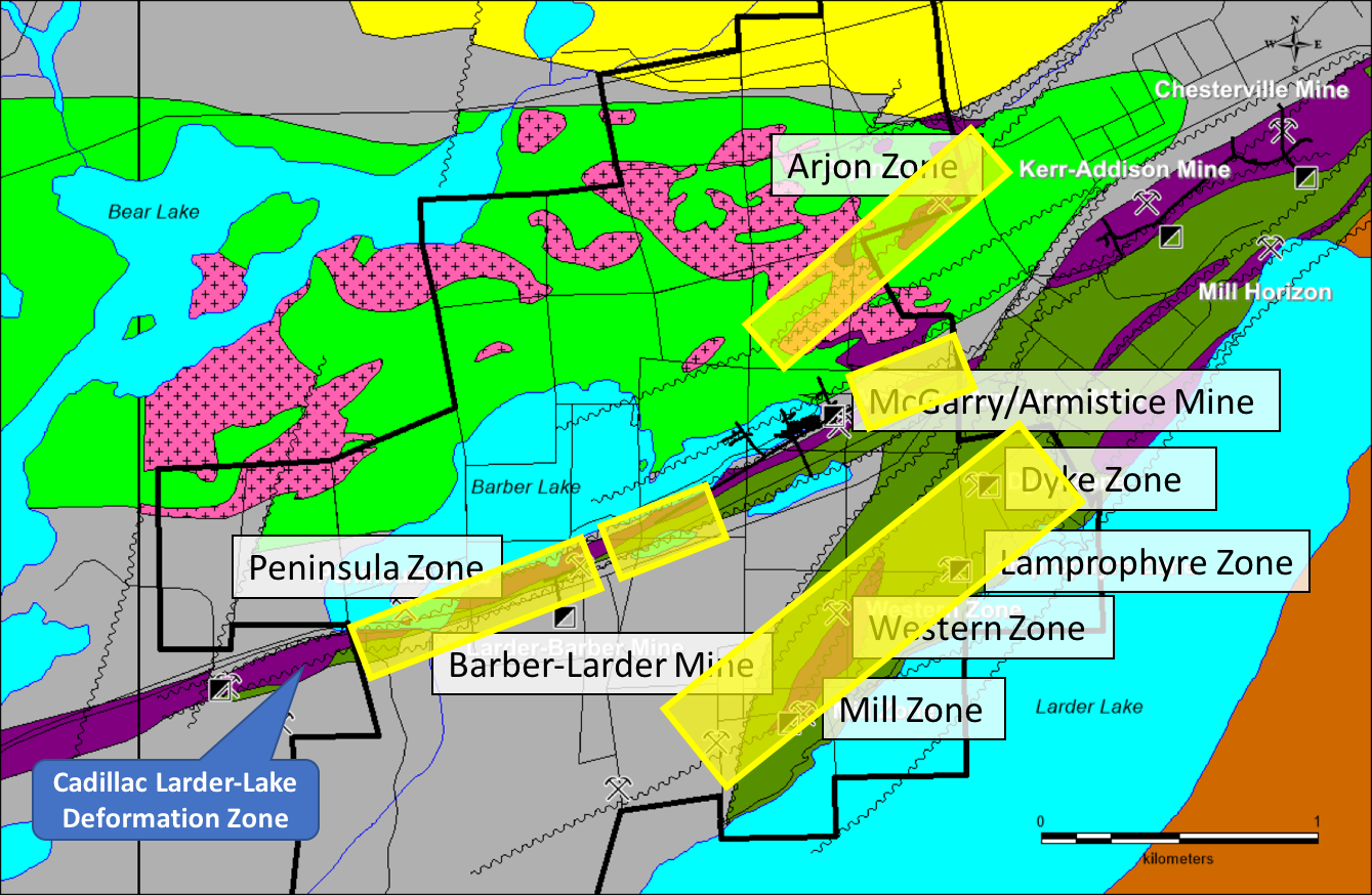
The McGarry Property is host to numerous gold mineralized zones, and many have only been drilled to a relatively shallow depth. The following is a summary of potential targets on the Property that merit follow-up (see Figure 2 for locations).
McGarry Mine
Development work by the previous owners has prepared the 325N Zone for production. This zone is of particular interest because of its high grades, as described above.
Exploration of the McGarry Deposit was quite extensive in and near the existing mining infrastructure. Generally, outside the shaft area between the 1,250 and 2,250 ft levels, exploration has been a lot less intensive. Considering the abundant underground infrastructure, the targets that can be pursued can be quite small. Between the shaft and the eastern limit of the Property, there is ample room for discovery. The proximity of the historic Kerr-Addison mine opens up the possibility of deep extensions of that deposit on the west side of the Armistice Fault, as suggested by north side down movement along the Larder Lake Break (see MNDM OFR5831).
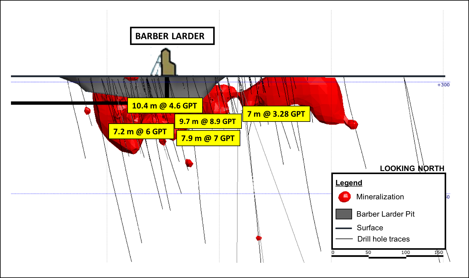
Barber-Larder Extensions
The Barber-Larder deposit was mined as a small open-pit by Golden Shield Resources between November 1987 and July 1988. Production bottomed out at approximately 46 metres. However, the deposit continues below at similar grades (see MNDM, AFRI 32D04SE0006). Moreover, beyond the top 120 metres vertical, the deposit has not been much explored. There are indications of significant gold mineralization down to at least 600 metres vertical, where a hole intersected a narrow 30 cm core length interval of 11.7 gpt gold.
The previous exploration identified a number of targets that merit follow-up to the west of the Barber-Larder deposit. Approximately 150 metres grid-west of the shaft, a hole intersected 1.8 meters grading 3.4 gpt gold. Thirty metres grid-east of this, another hole intersected 3.9 gpt gold over 3.5 metres.
Twenty-five metres east of the open pit, a drill hole intersected a 7.9-metre interval grading 7.5 gpt gold. Although there are only 330 metres between the eastern end of the old workings in the Barber-Larder mine (120 metres) and the western end of the 2,250 foot level in the McGarry Mine, the vertical distance is over 550 metres. Within this envelope, there is ample room for exploration.
Peninsula Zone
The Peninsula Zone is located along with the same package of deformed and altered rocks immediately west of the Barber-Larder Mine. A hole drilled near the peninsular island returned 3.4 gpt gold over a core interval of 6.1 metres at a vertical depth of 85 metres (see MNDM AFRI 32D04SE0006).
Mill Zone and Western Zone
The Mill and Western Zones are located in a northeast striking ultramafic unit that has been completely altered to carbonate. The Mill Zone is located at the southern end of the 750m long ultramafic unit and is cut off by an east-northeast trending fault. Drilling on this zone intersected up to 36.7 gpt gold over 2.1 metres.
The Western Zone is located near the northeastern end of the same altered ultramafic unit. The zone was trenched over 75 metres in length and indicated the presence of a small mineralized shoot approximately 15 metres long and 1.7 metres wide and assaying an average of 3.9 gpt gold (see MNDM AFRI 32D04SE0402).
The Dyke Zone
The Dyke Zone is located in the McGarry Property's southeastern corner and is hosted by an altered diorite or gabbro. The NE trending dike is fractured in places and contains quartz and calcite stringers with pyrite. The zone extended for over 300 metres and was sampled over about 100 m giving an average of 7.25 gpt gold over about 1.0 metres in width (see MNDM AFRI 32D04SE0402).
Lamprophyre Zone
The Lamprophyre Zone is located on the southeastern corner of the Property and is hosted by mafic volcanics of the Temiskaming Assemblage. The mineralized zone consists of a NE trending shear at the contact of a lamprophyre dike. Values up to 3.9 gpt gold are reported over 0.9 metres (MNDM, ARV050).
Arjon Zone
The Arjon Shear Zone is located in the northeast corner of the McGarry Property and extends to the northeast onto the adjacent Kerr Property. A few drill holes marked on a 1941 map (MNDM ARV50, MDC03) and mapping indicate the presence of sheared ultramafics rocks transformed into green carbonate. The map also shows some NE trending quartz veins several tens of metres long but no assays. None of these drill holes were compiled by later explorers and are of uncertain origin. The Arjon Shear is oriented NE and cuts the Blake River mafic volcanics, some altered Ultramafic Units, and the syenite porphyry. Only low-grade gold values (up to 2.8 gpt Au) were found on the occurrence as there was generally no interest in the past for bulk-minable targets. Little work was done after the 1930s. There is a description of a "Northern" crosscut on the adjacent Kerr property driven on the 2,500 foot level across the Temiskaming sediments into some mafic volcanics, which are presumably the Blake River Assemblage. This reference describes a 400 foot (122 metres) section of drifting in altered and sheared volcanics that assayed a minimum of 200 ppb over the whole interval with some higher grade sections within.
This target needs to be followed-up for its potential for intrusion-hosted bulk-minable gold mineralization.